Greater Cook Inlet Stratigraphic Palynology Control Database and Study
- Now available -
This stratigraphic control database consists of palynological biostratigraphy for 84 wells and one outcrop area in the Cook Inlet Region of south-central Alaska (see map and list below). Palynozones are plotted on well logs for 83 wells.
Nineteen stratigraphic intervals can be identified: twelve Tertiary and seven Mesozoic. The Tertiary intervals are driven primarily by climate. A stratigraphic framework is presented that relates the Tertiary intervals to well known, age-constrained data from outside the Cook Inlet Basin. The Mesozoic intervals are defined by traditional first and last appearance events.
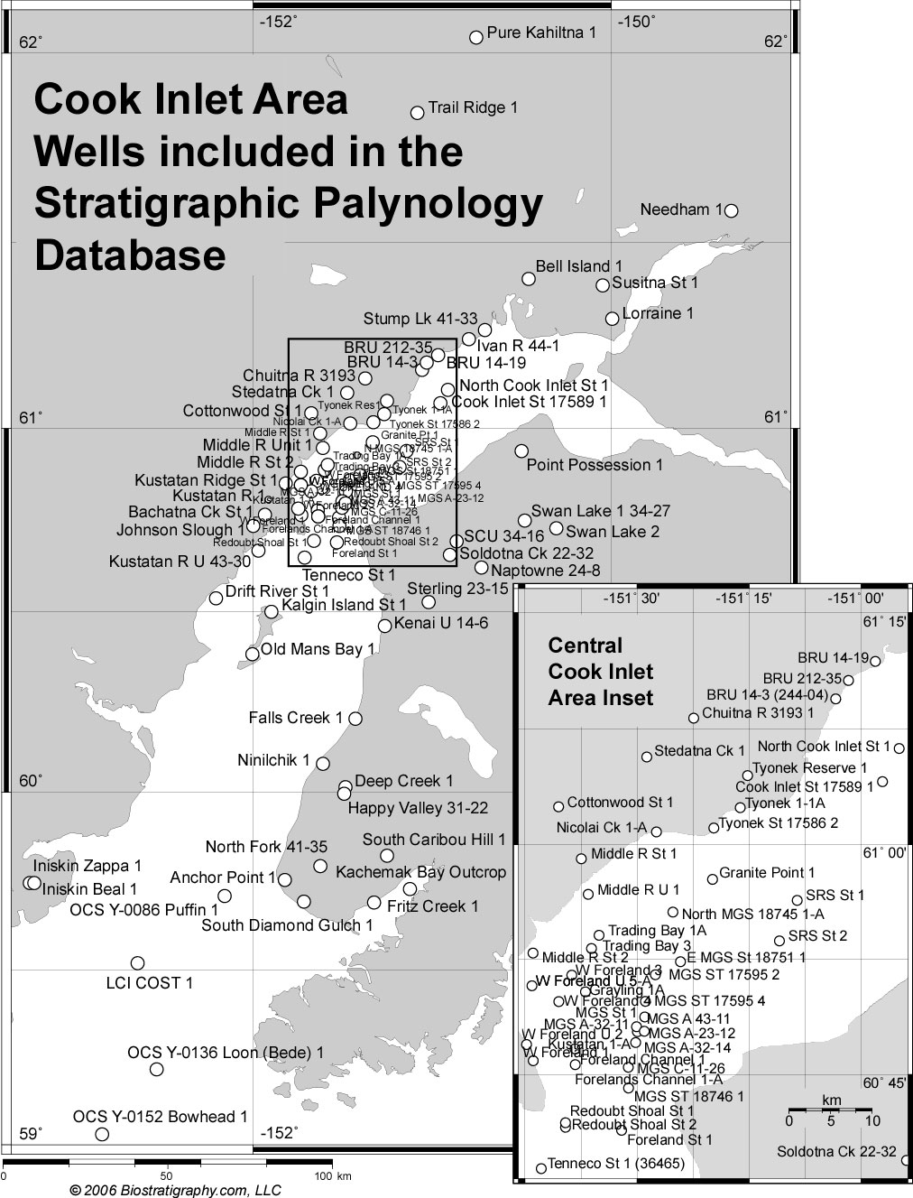 Location map of the 85 stratigraphic palynology records for the Greater Cook Inlet Region. Location map of the 85 stratigraphic palynology records for the Greater Cook Inlet Region.
The database was completed in December 2006.
The report consists of:
1) Explanatory text defining the palynozones in Cook Inlet
2) Chronostratigraphic calibration of the palynozones
3) Data reports in page format
4) Palynozones posted on well logs for 83 wells
5) Data table of wells, depths and palynozones
6) Supporting location maps and stratigraphic figures
The report is provided as:
1) PDF document (download Table of Contents pdf)
2) Data table
3) Fully functional, stand-alone database application
| Database specs: |
|
| Records in the database |
85 |
| Zones in the stratigraphic framework |
19 |
| Average number of analyses per well |
91 |
| Average number of zones per well |
7 |
| Number of samples in the database |
7735 |
| Database initiated 01/06 |
Complete 12/06 |
Uniqueness of the database: A comparable database does not exist. Although this work is based on previously acquired oil company palynology data, the zonal framework, final interpretations, and compilation are substantially expanded and very different than the 40-year-old data on which it is based. The original data was collected by multiple analysts, mostly during a 15-year period from the mid-1960s to the early 1980s.
Much effort was required to turn this paper data into a functional and reliable database. The raw data consisted of un-catalogued hand plotted charts with pollen types labeled in cryptic code. The pollen codes were decoded to botanical names. The charts were copied and digitized to numerical data. The data was error checked, combined into groups and transfer functions, then plotted in several visualizations. The new curve-data were interpreted in the context of global climate. A new palynostratigraphic framework, based on robust and reproducible characteristics (events) in this curve data, was developed and calibrated by tying the events to the global climate record, radiometric dates and other fossil age-constrained events. The calibrated palynology zones were then related to Tertiary megafloral stages and Cook Inlet lithostratigraphy. After the new palynostratigraphic framework was developed, the entire database was re-interpreted a second time to ensure consistent application of the new concepts. The interpreted events were integrated with well logs and location information and compiled into the final database.
The database and report are copyrighted.
© 2006 Biostratigraphy.com, LLC.
Purchase requires agreement to standard data license terms.
| Wells included in database |
API number (12 digit) |
| Anchor Point 1 |
502311000500 |
| Bachatna Creek State 1 (36448) |
501332017700 |
| Bell Island 1 |
502831001100 |
| Beluga River 14-19 |
502831002400 |
| Beluga River 14-3 (244-04) |
502832000200 |
| BRU 212-35 |
502831002700 |
| Chuitna River 3193 1 |
502831000600 |
| Cook Inlet State 17589 1 |
508831001200 |
| Cottonwood State 1 |
502832000100 |
| Deep Creek 1 |
501331000400 |
| Drift River State 1 |
507331001600 |
| East MGS St 18751 1 |
507331003300 |
| Falls Creek 1 |
501331000500 |
| Foreland Channel 1 |
507331004900 |
| Forelands Channel 1-A |
507331004901 |
| Forelands State (29691) 1 |
507332002400 |
| Fritz Creek 1 |
502311000600 |
| Granite Point 1 |
507331005900 |
| Grayling 1A |
507331004400 |
| Happy Valley 31-22 |
502311000100 |
| Iniskin Unit Beal 1 |
501211000800 |
| Iniskin Unit Zappa 1 |
501211000900 |
| Ivan River 44-1 |
502831000800 |
| J. M. Needham 1 |
500091000900 |
| Johnson Slough 1 |
501332017000 |
| Kachemak Bay Outcrop |
0 |
| Kalgin Island State 1 |
507331001500 |
| Kenai Unit 14-6 |
501331008900 |
| Kustatan 1-A |
507331004501 |
| Kustatan Ridge State 1 |
501332003000 |
| Kustatan River 1 |
501332015400 |
| Kustatan River Unit 43-30 |
507332012800 |
| LCI COST 1 |
552200000100 |
| Lorraine 1 |
500091000400 |
| MGS A-23-12 |
507331008400 |
| MGS A-32-11 |
507331008100 |
| MGS A-32-14 |
507331008500 |
| MGS A-43-11 |
507331008200 |
| MGS C-11-26 |
507332014500 |
| MGS ST 17595 2 |
507331006800 |
| MGS ST 17595 4 |
507331007000 |
| MGS ST 18746 1 |
507331006600 |
| MGS State 1 |
507331007700 |
| Middle River State 1 |
501332000500 |
| Middle River State 2 |
507332013800 |
| Middle River Unit 1 |
507332003400 |
| Naptowne 24-8 |
501331001700 |
| Nicolai Creek 1-A |
502831002001 |
| Ninilchik 1 |
501331000300 |
| North Cook Inlet State 1 |
508831001800 |
| North Fork 41-35 |
502311000400 |
| North MGS 18745 1-A |
507331004000 |
| OCS Y-0086 Puffin 1 |
552200000300 |
| OCS Y-0136 Loon (Bede) 1 |
552200000500 |
| OCS Y-0152 Bowhead 1 |
552200000600 |
| Old Mans Bay 1 |
507331000900 |
| Point Possession 1 |
501331003600 |
| Pure Kahiltna 1 |
502671000100 |
| Redoubt Shoal St 29690 1 |
507332004000 |
| Redoubt Shoal St. 2 |
507332004001 |
| SCU 34-16 |
501331013300 |
| Soldotna Creek 22-32 |
501331002200 |
| South Caribou Hills 1 |
502312000300 |
| South Diamond Gulch 1 |
502311000800 |
| SRS State 1 |
507331003700 |
| SRS State 2 |
507331003000 |
| Stedatna Creek 1 |
502831000700 |
| Sterling 23-15 |
501331001200 |
| Stump Lake 41-33 1 |
502832005500 |
| Susitna State 1 |
502831001000 |
| Swan Lake 1 34-27 |
501331002500 |
| Swan Lake 2 |
501331002100 |
| Tenneco State 1 (36465) |
507332003300 |
| Trading Bay 1A |
507331005200 |
| Trading Bay 3 |
507331005400 |
| Trail Ridge 1 |
502832006500 |
| Tyonek 1-1A |
502831002901 |
| Tyonek Reserve 1 |
502831000100 |
| Tyonek St 17586 2 |
502831002800 |
| West Foreland 1 |
501331002800 |
| West Foreland 3 |
507331004600 |
| West Foreland 4 |
507331003500 |
| West Foreland Unit 2 |
501331002700 |
| West Foreland Unit 5 |
507332009600 |
| West Foreland Unit 5-A |
507332009601 |
Call for pricing and further details.
This material is copyrighted - © 2006 Biostratigraphy.com, LLC. Purchase requires agreement to standard data license terms.
|